|
[I have been asked] for a comment on the fissures of what we used to refer to simply as "the shelf".
The puzzle raised, what calved and when, reminds me that we didn't allow Encyclopaedia Britannica
on base - because it would have shortened what were often wonderful arguments, the debate being far more
entertaining than the answer.
After my first relief, I did a trip out with Genghis through the Bob Pi to learn from that impresario of
understatement how to drive a dog team. We were actually both bloody frustrated trying to teach Seletar
to be a leader.
Then after winter, on 19th September 1970 John Nockels and I were dispatched with the Beatles:
| Seletar | Michelle | Frodo | Ratti | Mitya |
| Feddu | Gollum | Colic | Jock | |
Nominally Seletar leading, to recce the extent of the crack advancing eastwards from the Gin Bottle
and to recce a possible route across the Low Shelf to R.4.
A week out in foul weather, only 31 miles from base, John Nockels fell and dislocated his shoulder.
A keg brought Brian out to replace John, and left a small depot, Depot Nocker. Poor Brian; he had
a sh*t beginning. We spent the next 3 days lying up in a blow. The fourth day we only managed 8 miles.
My report says, "A terrible days sledging; Michelle on heat, punch-ups all the way, with all dogs
covered in blood except Michelle who was bleeding for another reason. Brian broke a ski.
Weather bloody, my hand bloody. Poor little Gollum died".
But then Seletar wised up and we did have 3 really good days travelling, covering 70 miles back to Base.
Poor Brian on half a ski but great credit to him, he never moaned once.
A number of points occur to me in no particular order of importance: -
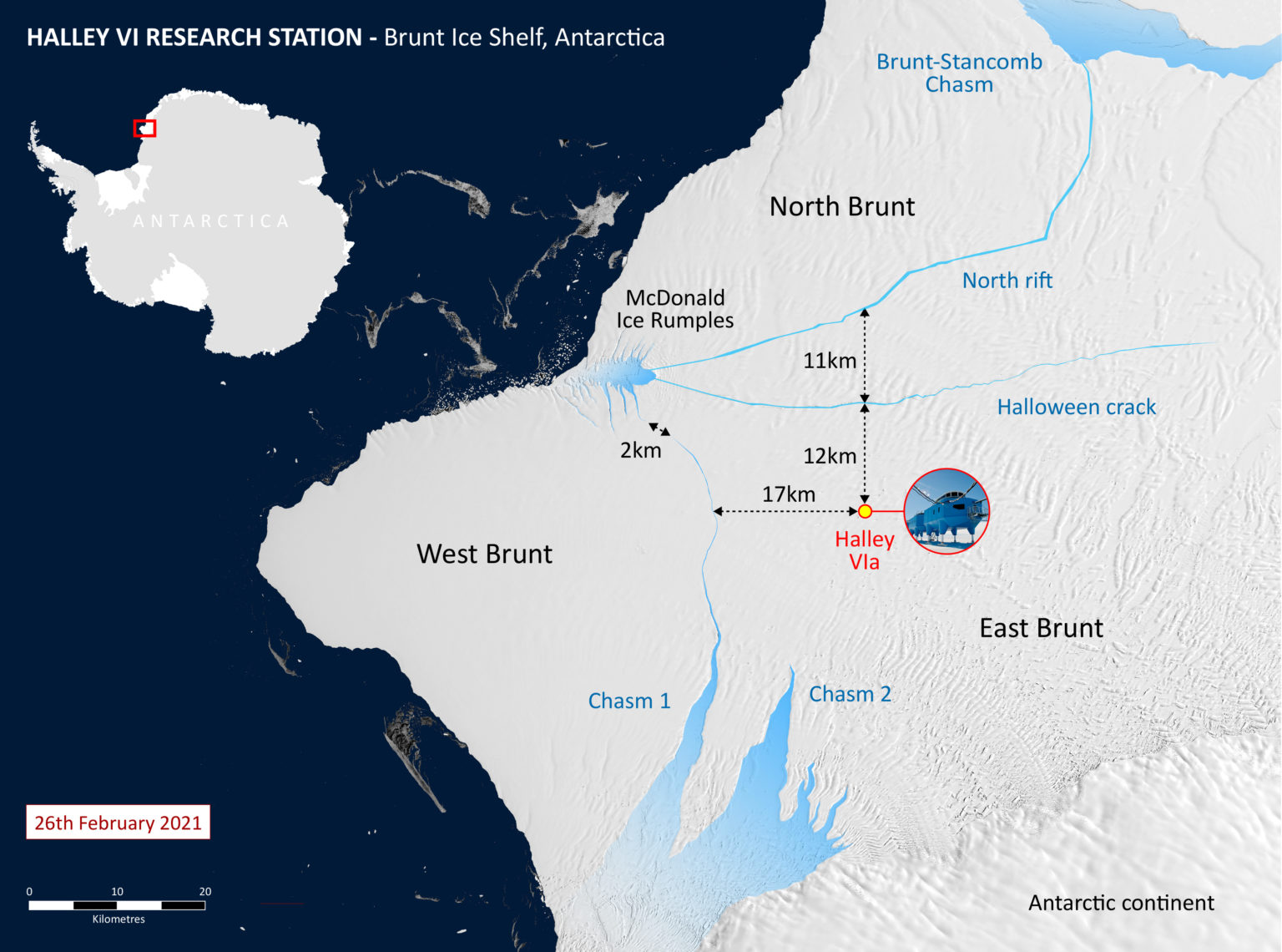
- I do like Tiff's map
on which he clearly states, "not remotely to scale".
On Tiffĺs map he shows the new crack heading on an approx bearing of 100 ESE from the Gin Bottle.
Is this a bit of Tiffĺs not to scale? Probably.
- On the map I made on my trip out with Brian Cornock, the crack from the Gin Bottle ran on a
bearing of approx 80 i.e. 20° different. I am fairly certain that the crack Brian and I followed
in 1970 is the same crack as Tiffĺs in 1969.
- By 26th September 1970, the crack extended 32.3 miles west of Base, but 2 days later on our
return journey we noted the crack had extended another 0.5 miles, so clearly extending before
things started to heat up after the winter freeze.
- Significant because the
BAS map
shows two cracks heading east from the Gin Bottle: Halloween Crack, which runs east from the Gin Bottle,
and North Rift, approx 70°, ie 20° different from Halloween Crack and more closely following
the line of the old crack Tiff describes in 1969.
In the 50-year interval since Brian and I were there I suspect the shelf has moved.
North Rift follows the same bearing as the crack we followed.
Has the Halloween Crack a bit further south come into existence since we were there?
Possibly, thatĺs my guess anyway. With the whole of the Brunt trying to head out west
into the Weddell, the pressure the Gin Bottle must be exerting must be causing huge
pressures on the shelf, enough to cause all sorts of splits.
- Iĺve digressed a bit, sorry. Now to the question: what calved in 1971?
- We were aware of a big berg slowly drifting past the Chips over the 1970 winter.
So I was lucky to be dispatched with Ron Loan the following spring to map the
new coastline to the north of Base with the Beatles, now:
| Seletar | Lassie | Craven | Frodo | Mitya |
| Chey | Colic | Ratti | Jock | |
- So at some time before 29th October 1971, from the Gin Bottle, the whole of the shelf on the
north side of Tiffĺs crack which continued past N3, past Depot Nocker, to and a bit beyond N9
(where I believe Reliefs after our time were carried out), some 35 miles east of Base,
all calved into the Og. Gone bye bye. Crack Depot gone. A route up to Grants Inlet gone.
Parts of a glacio line D19 D20 gone. I called this Boobooĺs Lost Bay.
- In our day I knew we were on floating ice something like 800 to 1000 feet thick.
What I didnĺt know was the height of the sea bed below the shelf ice. It would have been
fascinating to have seen a plan showing the contours of the sea bed to explain the Gin Bottle,
Christmas Box Hill and for that matter the Low Shelf. And until all the publicity about
Thwaites Glacier, I didnĺt appreciate that the underside of the ice shelf was being melted.
[25 Mar 2021]
|